PROJECT SITE MAPPINGS
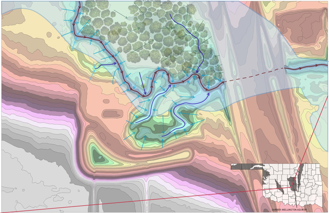
MAPPING for ELEVATION CHANGES and HYDROLOGY
The shaded contour lines make the elevation change more apparent, ranging from higher to lower and pink to blue respectively. The cooler the tone, the closer it is to the creek which is shown in a darker blue. The light blue flood plain extends mostly on these lower elevations, with the area south of the site at a high enough elevation to avoid flooding, but also directing all of the water towards the site. The site sits on the edge of the Garber-Wellington aquifer, which extends through several counties in central Oklahoma. This is important because the design of the site should minimize impervious surfaces so the water can replenish the ground water. The thinner the arrows designating runoff, the less runoff there actually is. A majority of the site is covered in trees, thus there will be less runoff as the vegetation absorbs some of this water. A few shallow ravines gather more runoff and direct it into the creek, which can flood significantly in heavy rainfall. It is critical that the building does not impede these crucial paths of stormwater runoff.
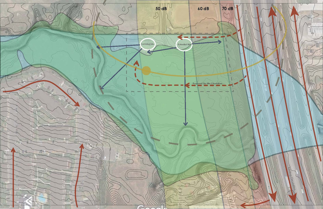
MAPPING for SOUND, CIRCULATION, SUN PATH, and VIEWS
The proposed location for the building within the site is based on several factors. Firstly is the proposed circulation. The sole source of vehicular traffic will be coming from the southbound frontage road on I-35, seen on the right-hand side -- the site would not be accessible from the roads to the west, since the site does not extend over the creek. Circulation will need to cut through the large amount of trees -- ideally cutting down as few trees as possible. It makes the most sense to do this on the very north or south side of the site. The north side would make it easier to cut down the edge of the forest with minimal erasure of green spaces, while the south could achieve a fairly narrow road that is obstructed from view of the building for a more aesthetically pleasing landscape. Related to this is the potential for views. For the most part, the views from the building would be towards the forest, as opposed to the somewhat barren field to the north of it. Looking to the west, it could be possible to get a glimpse of the creek.
Also important to the building location is the amount of highway noise. Sound decreases by approximately 10 decibels for every doubled distance from the source noise. Typically highway noise is about 70 decibels at 50 feet from the road. Using this information it can be approximated that at peak travel times with the maximum amount of cars, the sound on site could range from 40 to 70 decibels. It is mindful to locate the building as far west of the site to reduce the unpleasant noise. Additionally, the green area denoting tree cover could potentially reduce this sound as the trees block and absorb some of it. Based on this analysis I propose two possible locations for the building within the site, both situated on the northern side.
Also important to the building location is the amount of highway noise. Sound decreases by approximately 10 decibels for every doubled distance from the source noise. Typically highway noise is about 70 decibels at 50 feet from the road. Using this information it can be approximated that at peak travel times with the maximum amount of cars, the sound on site could range from 40 to 70 decibels. It is mindful to locate the building as far west of the site to reduce the unpleasant noise. Additionally, the green area denoting tree cover could potentially reduce this sound as the trees block and absorb some of it. Based on this analysis I propose two possible locations for the building within the site, both situated on the northern side.
